The Allapacoochee Creek
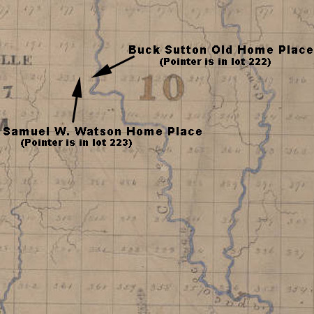
This brief entry will focus on the name of the creek that forms the eastern boundary of the W.H. Outlaw Farm. In 1885, my great grandfather Jerry S. "Buck" Sutton bought what became known as the Buck Sutton Old Home Place from his brother-in-law, Stephen M. Lewis. The warranty deed (Book U, page 131), in part, reads ". . . hereby grant bargain and sell unto the said J.S. Sutton . . .one hundred and fifty acres more or less of land lot number two hundred and twenty two in the tenth district of Berrien County being all the part of the said lot lying west of the Ten Mile Creek and north of Beaver Dam Bay also six acres of lot number one hundred ninety three in the tenth district of said county being that part of the said lot lying west of the Ten Mile Creek." Thus, the original lot line (222/223) separated the Sutton land to the east from the Watson land to the west over most of the joint land line. ******************* |
|
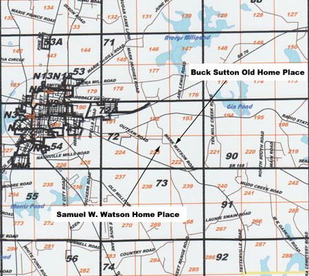 |
This modern map (Berrien County, Georgia, Tax Assessor's Office, 909 N. Davis Street, Suite G2, Nashville, GA 31639) is for orientation. The Mark Watson Road is Co. 94 on some maps. In this region, the land lots were 490 acres. Note that the numbering of the lots runs from east to west, then west to east, alternating. This apparent oddity stems from the surveyor's numbering sequentially on an east-west run, and doing a 180 and, again, numbering sequentially. The purpose of this map is to permit correlations on the basis of land lots with older maps, which lack features known to modern man (e.g., the city of Nashville, GA). N.B. My printed copy of this map had some distortions. Also, the roads/lot lines are not precise. Specifically, lot boundary 222/223 should be somewhat east of the position shown relative to Mark Watson Road. |
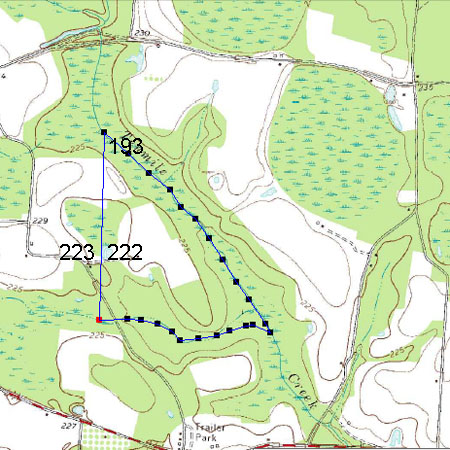 |
A second level of orientation is provided by this USGS topological map, which has mostly invariant features. Man-made features are easily picked up, too, e.g., the Radio Station Road at the top and Griner's Trailer Park at the bottom center. Superimposed on the USGS map is a very rough depiction of the Buck Sutton Old Home Place (using freeware downloaded from Terrago Technologies and integrated with Acrobat). The eastern boundary is the Ten Mile Creek whereas the western boundary is the original lot line and the property extends up into lot 193, as provided by the legal description given above. A main purpose of this map is to show the correct run of the creek (i.e., NW/SE at the boundary in lot 193. The historical maps below incorrectly show it to run N/S in this region). Link for zipped pdf of USGS map, Nashville_East. |
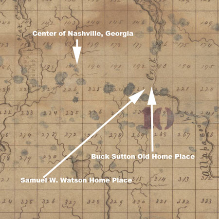 |
From Georgia's Virtual Vault Berrien County Map, 1866 B.A. White, Cartographer Should be cited as "County Maps, Surveyor General, RG 3-6-66, Georgia Archives. File name cmf0030.tif |
From Georgia's Virtual Vault Berrien County Map, 1869 Should be cited as "County Maps, Surveyor General, RG 3-9-66, Georgia Archives. File name cmf0426.tif |
|
On examination of the maps above (and several others), in sequence, it appears that the name Allapacoochee Creek in the 1860s had begun to morph into the Ten-Mile Creek by 1885. Why would this be true? Certainly, Allapacoochee is not unique (e.g. the Alapaha River was also known as the Allapacoochee River), but the "Ten-Mile Creek" is singularly unimaginative and also far from unique. (There is even another Ten-Mile Creek nearby in Georgia.) The only thing, so far as I know at this writing, is that Five Mile, Ten Mile et cetera do position the referenced name to a familiar landmark such as a county line. The suffix "coochee" means water (or creek or river) in the Muskogean language family, but I don't have a reference and hope I remember correctly. The first part of Allapacoochee might mean "grass," "on the other side," or "alligator." See previous link. Well, until I know differently, it will be Allapacoochee Creek, not the Ten Mile Creek. :) (Filed under Folder Outlaw since the current W.H. Outlaw Farm comprises all the Buck Sutton Old Home Place and takes in a portion of the orginal Samuel W. Watson Home Place.) Edit 2018-03-30: On the G. W. Colton 1856 World Atlas found on the David Ramsey site, the Allapacoochee Creek was known as Lyons Creek. Lyon(s) is a French surname/place name. The simplest speculation is that a family of this name lived on the creek. Support for that speculation might be difficult to find because of the Lowndes courthouse fires. Cursory looks at the census records do not show a Lyons living on the creek, but there were Lyons in the area, e.g. John Lyons (b. 1824, who moved to Irwin County between 1850 and 1860, and whose family moved into Lowndes later.) When I catch my breath, I will study topo maps to determine whether there might be an attractive bluff on which to settle, as the areas I know on the upper creek generally have swampy flood plains.
|
|
Return to Documentation for this page. |
|